FAQ & Troubleshooting
Answers to the most common questions about GPS Stakeout.
Getting Started
What devices does the app support?
GPS Stakeout requires an iPhone or iPad running iOS or iPadOS 17 or later. It works on all iPhones with iOS 17+, and all iPad models that support iPadOS 17 (including iPad mini 5th gen, iPad 6th gen, iPad Air 3rd gen, iPad Pro 2nd gen and newer).
Does the app work without an internet connection?
Yes — almost all features work fully offline. You can parse deed text, set GPS anchors, navigate to corners, and use AR mode without any network connection. The only exception is PLSS Section lookup, which queries the BLM GIS database and requires an internet connection. Map tiles (satellite and standard) also require a connection to load, though previously viewed tiles may be cached by Apple Maps.
What is a "plat" in this app?
In GPS Stakeout, a plat is a saved boundary — a set of corner points that define a property's shape. You create a plat from a deed description, a single bearing-and-distance line, a PLSS lookup, or manually entered coordinates. Once saved, a plat is your working unit: you anchor it to the real world, navigate to its corners, and visualize its boundary on the map.
Can I add just a single line — one bearing and distance?
Yes. On the New Plat screen choose the Line tab, enter one bearing and one distance (feet, metres, chains, rods, and more), and tap Create Line. The app builds a two-corner plat — your starting point and the far end. Stand on the first corner, tap Set as Reference (I'm Here), and the line appears on the map so you can navigate to the far corner. It's the quickest way to check a single property line or follow one deed call — no full deed needed, and it's free. See Single Line.
Can I use GPS Stakeout outside the United States?
Yes. Deed-text parsing and manual coordinates work anywhere in the world, and the parser reads both imperial and metric units (feet, chains, rods, and metres). Distances, GPS accuracy, and area can be shown in feet or meters — set it under Settings → Units. The preference defaults to your device's region (metric regions default to meters), and you can switch it any time. The one U.S.-specific feature is PLSS Section lookup, which draws on the U.S. Bureau of Land Management database; outside the U.S. it simply returns nothing, and you'd use deed text or coordinates instead. As always, the app shows approximate locations and is not a survey — for anything legal, consult a licensed surveyor in your jurisdiction.
How do I organize multiple plats?
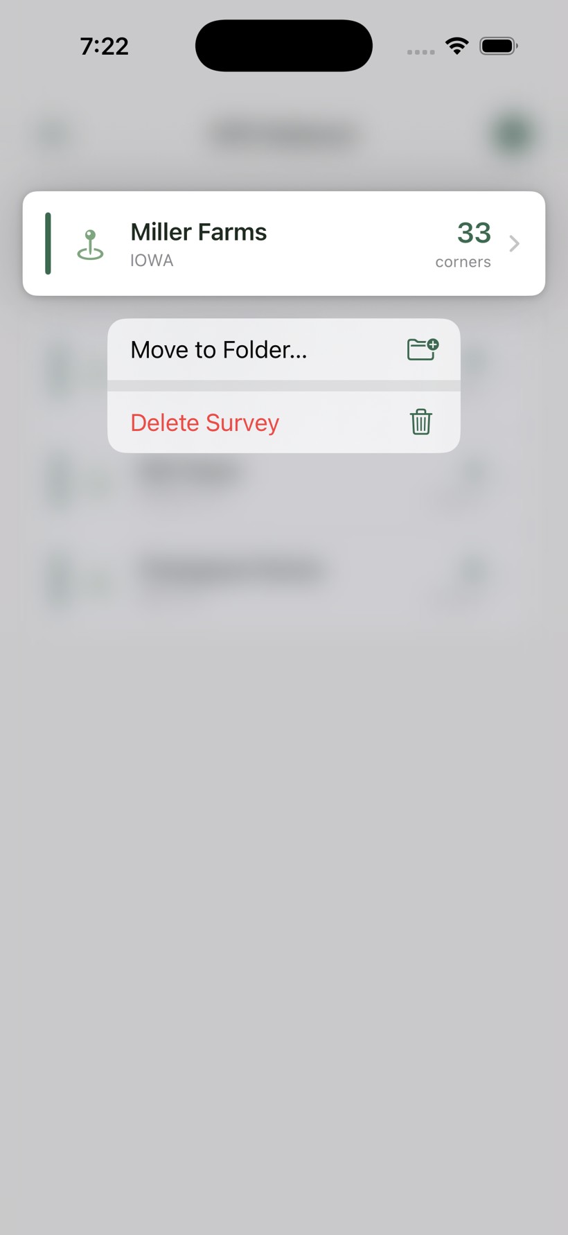
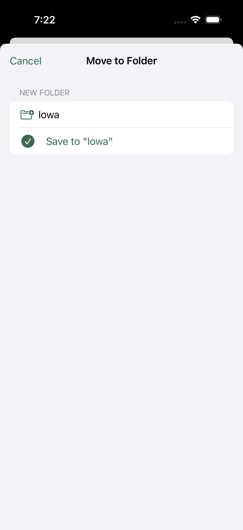
Press and hold any plat in the list to open its menu, then choose Move to Folder…. Pick an existing folder, or type a new folder name and tap Save to "…". You can name folders anything (e.g., "Home Tract", "Back 40"). The main plat list groups plats by folder, and recently opened plats appear at the top for quick access.
What are the tips that appear on the Corners and Map tabs?
Those are Guided Tips — short empty-state hints shown to new users on the Corners and Map tabs to point out the basics before you've saved your first plat. They're on by default. If you'd rather not see them (or want them back), toggle Guided Tips for New Users under Settings.
Free & Pro
What's included free, and what's Pro?
GPS Stakeout is free to download and use, with a one-time Pro upgrade that unlocks the full toolset. There is no subscription.
Free
- Add plats by pasting or typing a deed, scanning a printed deed with your camera, a PLSS section lookup, or manual coordinates
- Parse and view the boundary — a PLSS plat appears on the map immediately; a deed plat appears once you anchor a corner
- Save up to 2 plats
- Navigate to 2 corners per plat — a 3rd corner still shows live distance and bearing, dimmed, with Pro one tap away
- External GPS receiver support (sub-meter accuracy)
Pro (one-time unlock)
- Save unlimited plats
- Navigate to every corner on every plat
- AR boundary mode — corner stakes with name flags and a fence line pinned to the real ground
- KML export to Google Earth and other mapping tools
- KML import — bring in a boundary from Google Earth, county GIS, or a surveyor
- iCloud backup & sync across your devices
How do I upgrade to Pro?
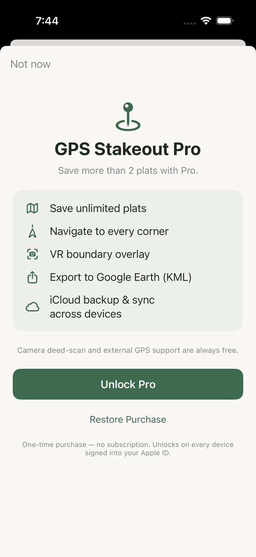
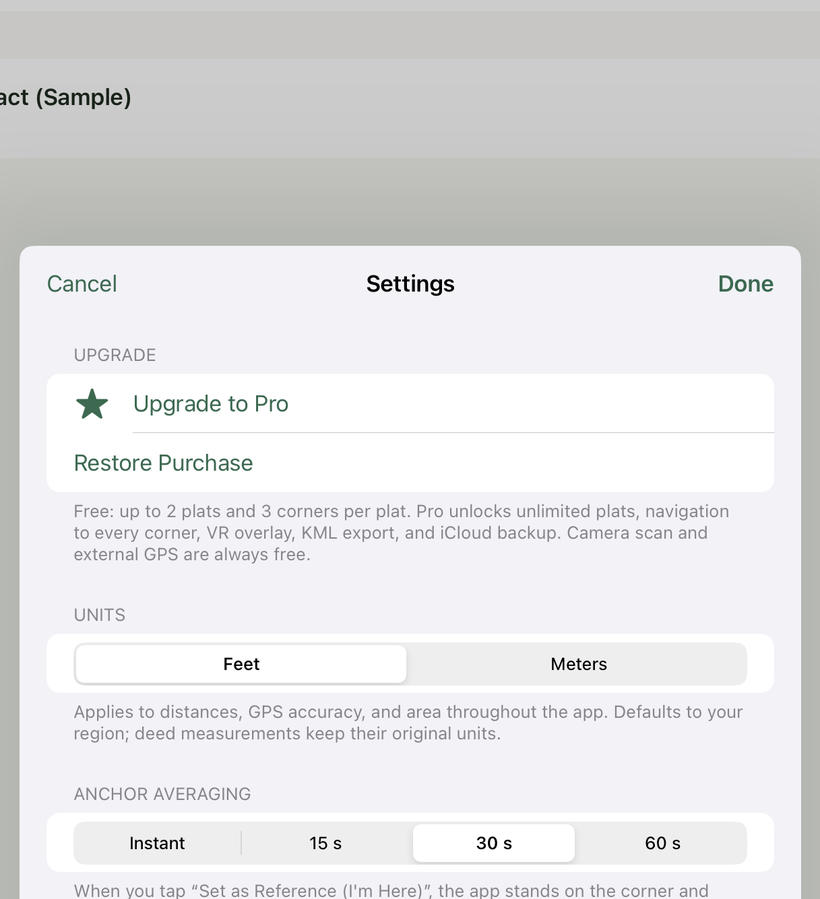
Tap any Pro feature — or go to Settings → Upgrade to Pro — and the upgrade screen appears with the current price. It's a one-time purchase, not a subscription, so there are no recurring charges. Camera deed-scan and external GPS support stay free either way.
I bought Pro — how do I get it on a new phone or after reinstalling?
Pro is tied to your Apple ID, so it usually restores automatically when you reinstall the app or sign in on another device with the same Apple ID. If it doesn't appear, open the upgrade screen or Settings and tap Restore Purchase. You are never charged again. Restore only works for the same Apple ID that made the purchase.
Does Pro include iCloud backup?
Yes. With Pro, your plats sync to your own private iCloud so they're backed up and available on your other devices. It activates the next time you reopen the app after upgrading. Your data goes only to your iCloud account (handled by Apple) — never to RiverTop or any third party. Free plats remain stored on your device.
Appropriate Use & Legal Boundaries
GPS Stakeout is a personal-awareness and professional field aid — for exploring your own property, and for licensed surveyors and their field crews. It shows approximate, deed-derived locations and is not a substitute for a licensed boundary survey. The notes below explain where the app fits, and where a licensed Professional Land Surveyor (PLS) is required.
Is GPS Stakeout a survey? Can it replace one?
No. The app navigates to where a deed or plat says a corner is, anchored by consumer GPS — an approximation, not a legal boundary determination. Only a licensed Professional Land Surveyor can establish, re-establish, or certify a property corner. Use GPS Stakeout for orientation and familiarity; hire a surveyor for anything legal, precise, or relied upon — fences and construction near a line, a sale, or a boundary disagreement.
Can I use it to find the corners on my own property?
Yes. Using the app on land you own, for your own awareness, is a personal use — not the regulated practice of land surveying. It's a great way to walk your deed, understand your parcel's shape, and get an approximate sense of where your lines run. Just keep in mind the positions are approximate and are not a certified survey, so don't rely on them for legal decisions.
Can I locate corners for other people, or offer a "corner-finding" service?
Not without a license. In most jurisdictions, locating, determining, or representing property corners for others — including with GPS — is the practice of land surveying and requires a licensed Professional Land Surveyor. Advertising such a service, even before doing any work, can itself count as offering to practice. The legitimate way to do this work is as a field technician under the supervision of, and with responsibility assumed by, a licensed PLS.
I'm a real estate agent — can I use it to show buyers the corners?
Use it for your own property awareness before a showing — to understand a parcel's general shape and layout from the recorded plat. When you talk with a client, speak from the recorded plat and keep it approximate: "per the recorded plat, the line runs generally here — a survey is the only way to confirm the exact corners." Do not determine or present corner or boundary locations to a client as fact. Doing so is both regulated surveying activity and a misrepresentation risk, and most brokerages and E&O carriers advise against representing lot lines.
Can hunters, land managers, or timber crews use it?
Yes — for orienting yourself on land you own or lease. It's well suited to walking your ground, planning, and general familiarity. As with any use, the positions are approximate, and you shouldn't use them to represent boundaries to someone else.
This is general information, not legal advice. Surveying-license rules vary by location and change over time — confirm your intended use with the licensing authority in your jurisdiction before offering any service.
Deed Text & Parsing
Why won't my deed text parse?
The most common reasons:
- The description has neither the word thence separating the calls nor one bearing per line. The parser reads either a standard "thence" description or a plain list with one course per line (see Advanced: How Parsing Works below).
- The bearing format isn't recognized. Try simplifying to "N 45 degrees 30 minutes E" or "N45°30'E" format.
- The text was copied from a PDF with hidden formatting characters or line-break hyphens. Try pasting into a plain text editor first to clean it up, then copy again.
- The description is a lot-and-block description (e.g., "Lot 4, Block 2, Woodland Heights Subdivision") rather than a metes-and-bounds description. There are no bearings or distances to parse — the app will recognize this and point you to the recorded plat, whose boundary calls you can then type or scan.
What bearing formats are supported?
The parser accepts a wide range of formats for the same bearing:
- Compact symbol: N42°30'15"E or N42°30'E
- Decimal degrees: N42.504°E
- Spelled out: North 42 degrees 30 minutes East (number words like "forty-two" are also recognized)
Distances can be in feet, chains (ch), or rods/perches (rd). Numbers may be written as digits or spelled out in English.
What is a "closure error" and should I be concerned?
A closure error is the gap between the last corner of the traverse and the starting point (Point of Beginning). In a mathematically perfect deed, the traverse closes back to exactly where it started and the closure error is 0.00 ft. In practice, real deeds often have small errors of a foot or two due to rounding in the recorded distances and bearings.
A closure error under 2–3 feet on a typical residential or farm parcel is normal and won't affect your ability to find corners. A large closure error (tens of feet) usually indicates a transcription error, a missing leg, or a meander call that doesn't represent a straight line.
My parcel plots rotated — the near corners fit but far ones drift. Why?
That's the classic sign that the deed's bearing basis differs from what the app assumed — the shape is right but the whole parcel is turned a few degrees, so the error grows with distance from your anchor. It's most common on older deeds measured from magnetic north. Open the plat, tap the ⋯ menu, choose Bearing Basis, and set the reference (True, Grid, Magnetic, or Assumed); for Magnetic you can fill the declination straight from the device compass. The app pre-selects the basis automatically when the deed text names one.
Not sure which basis it is? Use the optional two-point calibration: anchor two known corners in the field, then open the ⋯ menu → Bearing Basis and tap Solve rotation from these corners — it fits the parcel to your two measured points. Use it only when a deed genuinely plots rotated; if corners already land on the stakes, leave it alone. See Understanding Survey Systems for the full explanation.
What is a meander call?
A meander call is a deed clause that follows a natural feature — usually a creek, river, or ridgeline — rather than a fixed bearing and distance. Example: "thence with the meanders of Dry Fork in a southwesterly direction, 680 feet, more or less, to the point of beginning."
The app treats meander calls as a single straight leg using the stated distance and approximate direction. This is an approximation — the actual boundary follows the water's edge, which curves. The straight-line leg the app draws gives you the approximate location, but the exact boundary depends on the current water channel position.
My deed has a "Beginning at…" clause before the first thence — is that a problem?
No. The parser ignores the preamble before the first thence and starts reading boundary calls from there. The "Beginning at…" clause describes the Point of Beginning (POB), which becomes Corner 1 in the plat. You'll set the GPS anchor at that same physical location when you're in the field.
Are deed descriptions always written clockwise?
No — there's no legal requirement. Deed traverses can run either clockwise or counterclockwise around the parcel.
The POB drives the direction, not the other way around. The surveyor starts at whatever monument is most identifiable — usually a road intersection, an iron pin already in the county records, or a corner shared with an adjacent recorded lot — and then traverses whichever direction follows naturally from there along the first boundary.
Older deeds in the South frequently run counterclockwise when the POB is on a road, because surveyors tended to start at a road corner and head along the road first, which often meant going counterclockwise around the interior.
What matters legally is that the traverse closes back to the POB and the description is unambiguous. The shape of the lot is identical regardless of which corner you start at or which direction you go — the app plots the same polygon either way.
Does it handle curved boundaries (curve calls)?
Yes. Curves are common along cul-de-sacs and road frontage — for example "thence along a curve to the right having a radius of 432.00 feet, an arc length of 150.76 feet, and a chord bearing of North 78°00'00" West and a chord distance of 150.00 feet."
The app reads the chord bearing and chord distance — the straight line between the curve's two endpoints — to place the far corner exactly where it belongs, and draws the arc along the boundary. For staking, the corner is what matters, and it lands correctly.
A curve call needs both a chord bearing and a chord distance. If a curve is described only by a radius and arc length with no chord, the app flags that leg with a warning so you can verify it against the recorded plat.
Advanced: How Parsing Works
How does the parser tell a boundary call from ordinary text?
It anchors on the bearing — a compass letter, some numbers, then another compass letter (for example N 33 02 E). Almost nothing in ordinary legal prose matches that pattern by accident, so the parser can find the real courses inside a much larger block of text and ignore the rest. For each bearing it finds, it then reads the distance that follows.
How much extra text can I safely leave in the paste or scan?
Quite a lot. Because the parser only reacts to bearings and distances, the surrounding material is simply invisible to it. You can normally paste an entire legal description untouched — the opening recital ("being the same property conveyed in Book 412, Page 88…"), the closing paragraph ("containing 2.18 acres, subject to easements of record"), monument descriptions ("to a 1/2" rebar at the northeast corner"), dates, parcel IDs and page numbers all fall away because none of them is a bearing, and in a "thence" description a distance has to carry a real unit (feet, chains, a foot-mark), so a stray number like an acreage or a date is never mistaken for one.
Two things are worth trimming by hand:
- Directional narrative that looks like a bearing. A sentence such as "North 200 feet, then East along the fence" can pattern-match as a course. This is the main false positive to watch for.
- An adjoining owner's calls. On a survey plat, a neighbor's bearings and distances are often printed right alongside yours. Those can be read as extra legs, so remove them if you're transcribing from a plat.
Can I paste a plain list with no "thence"?
Yes. If there's no "thence" but two or more lines each start with a bearing, the parser reads it as a one-course-per-line list. It groups each line by its bearing, so the distance stays attached to its bearing even if a two-column layout puts them far apart or wraps the distance onto its own line. Distances in a list can be written with a unit ("150.4 feet"), a foot-mark ("150.4'"), or — in a clean list — as a bare number ("150.4").
A number is clearly there, so why does a leg say "no distance found"?
Usually the distance token was mangled and no longer reads as a number. Common causes are a transcription or OCR slip — a digit read as a letter ("292.7" → "292,T"), a decimal split by a space ("150.4" → "150. 4"), or a foot-mark that came through as a stray character. In a bare-number list the parser also insists on exactly one number after the bearing — if a line is garbled enough that two numbers survive, it skips the leg rather than guess a wrong distance. In every case it prefers to skip and warn over inventing a course, so a problem shows up as a missing leg, not a silently wrong corner.
What is the "from:" line under each parsed leg?
After you tap Parse, each leg shows the exact snippet of text it was read from. Use it to confirm the parse: every leg should trace back to a real course, and the "from:" text lets you spot a leg that was accidentally pulled from a sentence or an adjoining call. If a leg looks wrong, its source text plus the Warnings above it will tell you why.
Typing or the camera scan — which is more reliable?
Both work well. Typing is exact. The camera Scan Deed Document button uses on-device text recognition and rebuilds two-column "bearing / distance" tables into proper rows, so it reads a clean printed or neatly handwritten list reliably. Whatever the source, glance at the parsed leg count and the warnings before you save — the parser skips and warns rather than inventing a course, so any problem shows up as a missing leg, not a silently wrong corner.
Why did my closed parcel come in with an extra corner?
A hand-entered list rarely closes to the inch, so the last corner can land a few feet from the start. When that gap is small relative to the parcel, the app snaps the final corner onto the Point of Beginning and numbers the corners cleanly 1…N. If the gap is large — roughly a tenth of the perimeter or more — it leaves the traverse open (N+1 corners) and warns you, because that usually means a course is missing or misread, not that the parcel fails to close. A partial boundary (say, the non-road sides only) is the common reason a list is genuinely open.
Two of my courses are identical and back-to-back. Is that wrong?
No. Two sequential legs with the same bearing and distance are legitimate — the parser keeps both and does not de-duplicate them.
PLSS Section Plats
Do I need to GPS-anchor a PLSS plat?
No. PLSS plats are placed on the map automatically using official BLM CadNSDI coordinates the moment you save them. No GPS anchor step is needed — the corners appear at their surveyed locations immediately. You can navigate, export KML, and use AR mode without ever setting a reference.
On a PLSS plat, what can actually move my corners off the BLM positions?
Only one thing: deliberately tapping Set as Reference (I'm Here) on a corner. That is the single action that re-anchors a PLSS plat, and it always warns you first if your GPS is more than 1,000 feet from that corner's BLM position (see the proximity alert below).
Everything else leaves the BLM coordinates exactly where they are. Opening the plat, navigating, tapping Navigate Here, switching tabs, and viewing the map never re-anchor a PLSS plat. So if you didn't intentionally hit the anchor button, your corners have not moved — they're still on the surveyed BLM positions they were placed on at import.
And even if you did anchor by mistake, nothing is lost: the original BLM coordinates are stored permanently and Reset to BLM Position restores them at any time.
I accidentally anchored my PLSS plat while standing in the wrong location. How do I fix it?
Open the plat, go to the Plat Info tab, and tap Reset to BLM Position. This restores all corners to the original BLM-surveyed coordinates, discarding any field adjustments. The BLM reference coordinates are stored permanently when you import a PLSS plat and are never overwritten — Reset to BLM Position always has something to restore from.
Why did I get an alert saying my GPS is far from the recorded position?
When you tap Set as Reference (I'm Here) on a PLSS plat, the app checks whether your current GPS position is within 1,000 feet of the BLM-recorded position for that corner. If you're farther away, you'll see an alert with the distance. This prevents accidentally shifting a section boundary to the wrong state or county — for example, if the plat is in one state but your phone is in another.
If you want to proceed despite the distance (for example, if you know the BLM data for that area carries a documented offset), tap Anchor Anyway. Otherwise tap Cancel and use Reset to BLM Position if needed.
Why doesn't "Navigate Here" re-anchor when I'm on a PLSS plat?
On deed-text plats, tapping Navigate Here re-anchors the boundary to your current GPS position before switching to the Navigate tab — this is necessary because deed-text plats don't have absolute coordinates until you anchor them. On PLSS plats, the BLM coordinates are already authoritative, so auto-anchoring to your current location would move the section boundary away from its surveyed position. The app skips the re-anchor and sends you straight to Navigate with the BLM coordinates intact.
If you genuinely do want to re-anchor a PLSS corner to your measured position — say you're confirming a monument you've physically located — use the explicit Set as Reference (I'm Here) button on that corner instead. That's the only action that intentionally moves BLM corners, and it will confirm with you first if you're more than 1,000 feet away.
Can I look up a quarter section, not just a whole section?
Yes. Add the aliquot part right in the same PLSS field, e.g. "NE¼ of Section 14, T2S R5E" for a quarter section (160 ac), "NE¼ NW¼ Section 14" for a quarter-quarter (40 ac), or a third level for a 10-acre citation like "NE¼ NE¼ NE¼ of Section 14". The app subdivides the section's own corners geometrically to place the smaller parcel — an estimate, not a separately-surveyed BLM record, and it's always labeled that way (see PLSS Section → Quarter Sections & Smaller Parcels). Old shorthand with no fraction slash (e.g. "NE4NW4") and Government Lot citations aren't supported yet.
GPS & Accuracy
What does the ±ft accuracy number mean?
The accuracy figure (e.g., ±5 ft) is the horizontal position error reported by the GPS source — either your device's built-in chip or the connected external receiver. It means the true position is statistically likely to be within that radius of the displayed position. Lower numbers are better.
- ±1–3 ft: Excellent — sub-meter external receiver with a good satellite fix
- ±5 ft: Good — suitable for setting anchor and navigating to corners
- ±10–15 ft: Fair — usable but expect some positional uncertainty
- ±30 ft or more: Poor — not reliable for corner work; move to an open area or wait for better satellite geometry
The app shows the accuracy reading in the Set Reference dialog so you can decide when the signal is good enough before anchoring.
Why does the accuracy reading jump around?
GPS accuracy varies continuously as satellites move across the sky, atmospheric conditions change, and nearby obstructions reflect signals (multipath). Standing near buildings, under dense tree canopy, or in a valley will degrade accuracy. If your reading is poor, try moving to a more open area and waiting 30–60 seconds for the chip to reacquire satellites.
Does the app work on a WiFi-only iPad?
The app installs and most features work, but a WiFi-only iPad has no GPS chip. It uses WiFi positioning, which is typically accurate only to 15–30 meters — far too imprecise for corner navigation. You must connect an external Bluetooth GPS receiver to use the app meaningfully on a WiFi-only iPad. The app displays a warning banner when GPS accuracy is insufficient.
How accurate is the navigation overall?
Navigation accuracy is determined by two independent factors: the accuracy of your GPS anchor (set at Corner 1) and the accuracy of the deed description itself. If you anchor at ±5 ft and the deed closes cleanly, you can expect to arrive within 5–10 feet of the true corner monument. With an external dual-band GPS receiver in open sky, sub-meter arrival is achievable on well-surveyed parcels.
The deed description introduces its own uncertainty — recorded distances and bearings are often rounded, and older surveys used chains and compasses with limited precision. This app navigates to where the deed says the corners are, not necessarily where a licensed surveyor's monument is physically set.
What is the confidence meter, and what does it actually measure?
The four-bar meter shows how much to trust your current position. It's driven mainly by how far your fix wanders while you stand still — the honest measure, because a receiver's own accuracy claim can't detect multipath. A unit can report ±5 ft while sitting 14 ft from the truth.
High — steady and both receivers agree; good moment to anchor. Good — fine for navigating, acceptable for anchoring. Fair — navigate, but wait before anchoring. Low — don't anchor, let it settle.
Important caveat: it measures steadiness, not correctness. A reflected signal can hold a wrong position very steadily. That's why High requires a second receiver to corroborate — with only one receiver live, the meter caps at Good. While you're walking it can't measure wander at all (your own travel would look like scatter), so it says "Moving — stand still to measure." See Accuracy & Anchoring.
I reached the stake but the app says I'm still 20 ft short. Why?
Work through these in order:
1. Give it a few seconds. If the number counts down while you stand still, the receiver's position is settling — that's normal, especially under canopy.
2. Check the confidence meter. Fair or Low means the reading itself is unreliable; the boundary may be fine.
3. Check your anchor quality. The Corners tab shows "Anchored at ±X ft". That number is a floor on every arrival — a plat placed from a ±15 ft anchor cannot land closer than about 15 ft.
4. Don't fix it by re-anchoring. Tapping "I'm at this corner" here would slide the whole boundary onto a fix you already have reason to distrust. See the next question.
Why shouldn't I tap "I'm at this corner" every time I arrive somewhere?
Because on a corner that's already placed, that action slides the entire boundary so the corner lands on your current fix. That's correct when you're deliberately re-placing the plat from a monument you trust. It's the wrong move when you've just arrived and the distance looked off — you'd be re-anchoring on a suspect fix and dragging the whole parcel with it. The next leg then starts from a displaced boundary, and results swing back and forth between walks.
The app warns you when anchoring would move the boundary further than your fix quality justifies, showing the shift distance and the fix accuracy. "Keep current placement" is the safe default. Anchor once, deliberately; after that treat arrival distances as information, not corrections.
Why does the app average GPS fixes when I anchor?
A single instantaneous fix carries the receiver's full scatter, which under tree canopy can be 10–15 ft — and that error is then baked into every corner of the plat. So instead of taking one reading, the app occupies the point: it collects fixes for a set period, rejects outliers, and anchors on the average. This is standard surveying practice.
Choose the duration in Settings → Anchor averaging (Instant, 15 s, 30 s, or 60 s; default 30 s). Use 60 s for anchors you plan to solve a rotation from. Averaging removes the random component well, but multipath is partly correlated over time so it won't vanish entirely — standing longer helps, as satellite geometry shifts while you wait.
My two-point rotation solve gives a different answer every time. What's wrong?
Almost certainly your anchors are too close together. The solve infers rotation from the direction between two anchored corners, so the angular error is roughly (position error ÷ baseline). With 14 ft of GPS scatter that's ±5.6° on a 142 ft baseline — larger than most rotations you'd be trying to measure — versus ±1.6° at 500 ft.
Fix it by anchoring the two most distant corners you can reach, occupying each for 60 s, and solving once. Anchoring more corners helps further: a fit across five corners has far more redundancy than one across two. The app warns you when your baseline is too short for the result to be meaningful.
The solved rotation says "−2.34° W". What does the sign mean?
It uses the same convention as magnetic declination: + is East, − is West. So −2.34° W means the deed's bearings sit 2.34° west of true north.
That lets you compare it against historical declination for your area. If the deed used magnetic bearings, the rotation should roughly match the declination at the time of the original survey, which may be decades ago. A rotation matching no plausible declination usually indicates an assumed meridian — an arbitrary basis tied to a fence, road, or earlier plat. Be careful reading too much into a small number, though: a degree or so is well within what an arbitrary basis could be by chance. Only a basis-of-bearing statement on the document settles it.
Why does it matter which receiver I anchor with?
Corner positions live in the coordinate frame of whichever receiver measured them. If you anchor with the iPhone and then navigate with an external receiver, any difference between the two goes straight into your arrival distance as a constant offset in a fixed direction — it does not average out.
The app pins navigation to the receiver that captured your anchor and shows a lock icon beside the source name. If you later navigate on a different receiver it warns you, and it flags a rotation solve whose anchors came from different receivers. Tapping "I'm Here" always re-evaluates and re-pins to the best receiver available at that moment, so switching receivers in the field just means re-anchoring.
Setting a Reference (Anchor)
Why does my plat appear in the wrong location on the map?
A deed-text plat is a relative traverse — it describes the shape of the parcel but not its real-world position. Because it has no coordinates yet, the boundary does not appear on the map until you anchor a corner. Once you walk to your Point of Beginning and tap Set as Reference (I'm Here) — or use Set Location Manually to enter known coordinates — the app calculates every corner's position and the entire boundary appears at its true location on the map. (A PLSS section plat is different: it carries official BLM coordinates from import, so it shows on the map immediately, no anchoring needed.)
If the plat is in the right area but shifted, it usually means the anchor was set before the GPS had a good fix. Try setting the reference again with a better accuracy reading.
What's the difference between "Set Reference" and "Set Location Manually"?
Set as Reference (I'm Here) uses your current GPS position to anchor the corner. You physically walk to the corner location and tap the button — the app captures your GPS coordinates at that moment and uses them to place the entire boundary.
Set Location Manually lets you type in known decimal-degree coordinates (e.g., from a county GIS website or a surveyor's plat) without needing to stand at the corner. This is useful when you have coordinate data for the Point of Beginning but are doing the anchor setup from your desk before heading to the field.
Can I anchor from a corner other than Corner 1?
Yes. While Corner 1 (the Point of Beginning) is the natural anchor point, you can set the reference at any corner. Open the Corners tab, tap the corner you're standing at, and choose Set as Reference (I'm Here). The app will back-calculate all other corner positions from that anchor. This is useful when Corner 1 is inaccessible (behind a fence, in a creek) but another corner is easy to reach.
The "I'm at Corner X — anchor here" banner appeared. What does that mean?
When you're navigating to a corner and the distance drops below a threshold, the app detects that you may be standing at a corner other than the current reference and shows a smart prompt suggesting you anchor there. Tapping it sets that corner as the new reference, which can improve accuracy if the current anchor was set with a poor GPS fix. You can dismiss the banner and continue navigating if you don't want to re-anchor.
If I re-anchor after the plat is already placed, does the app recompute the shape?
No. The first time you anchor a deed-text plat, the app walks the deed legs to compute every corner from your anchor point. After that, each time you tap Set as Reference (I'm Here) the app slides the entire boundary so the corner you tapped lands on your current GPS position — it does not re-run the traverse.
This is deliberate: it preserves the exact surveyed shape (even if one or two legs have a slightly wrong bearing) and lets you use any corner as your "I'm here" pin without the lot snapping to a different shape each time. Re-anchoring at a second corner is the normal way to check your work — walk to another monument, tap it, and see how closely the boundary lines up.
The trade-off: because re-anchoring only shifts the placed boundary, it carries along whatever error was in the original placement. If your first anchor was set on the wrong corner or with a bad GPS fix, sliding it won't fix the underlying shape — you need a clean recompute. That's what Clear GPS positions is for.
What does "Clear GPS positions" do, and when should I use it?
On a deed-text or manual plat, Clear GPS positions (at the top of the Plat Info tab) removes every anchor and computed coordinate, returning the plat to its un-placed, shape-only state. Your deed legs, corners, and closure error are untouched — only the real-world placement is discarded. The next time you tap Set as Reference (I'm Here), the app starts fresh and recomputes the whole traverse from that anchor.
Use it when the placement itself is wrong and re-anchoring won't fix it:
- You anchored on the wrong corner and the boundary is now built off the wrong starting point.
- Your first anchor was set with a poor GPS fix (weak signal, before an external receiver locked in) and every corner is shifted as a result.
- You simply want to start the placement over from a known-good fix at a corner you can positively identify.
- You want to re-solve a rotation with a fresh set of anchors. Anchors are remembered between visits and the two-point solve uses all of them, so old or mismatched anchors corrupt the fit — clear first, then anchor only the corners you want to solve from. (Clearing also erases any previously solved rotation.)
The button only appears once at least one corner is anchored. On a PLSS plat this same button reads Reset to BLM Position instead — rather than wiping the placement it restores the authoritative BLM-surveyed coordinates, because a PLSS plat always has an official position to fall back to. A deed-text plat has no such fallback, so clearing it truly un-places it until you re-anchor.
Navigation
Why doesn't the bearing update when I'm standing still?
GPS bearing is calculated from your direction of movement — the chip compares successive position fixes to determine which way you're heading. When you're stationary, there's no movement to calculate from, so the bearing freezes or jumps erratically. Walk a few steps in a consistent direction and the bearing will stabilize and track correctly.
This is different from a compass, which measures magnetic heading independent of movement. The navigation screen uses GPS-derived bearing so it isn't affected by compass calibration or magnetic interference.
The distance shows 8 feet but the bearing seems to point behind me. What's happening?
At very short distances (under about 15 feet), small GPS position errors can make the bearing appear to swing unpredictably. This is normal and expected — GPS isn't designed to be directional at sub-10-foot scales. When you're this close, rely on the distance reading, not the bearing. Slow down, let the GPS position settle for a few seconds, and look for the physical corner monument (pin, pipe, or stake).
The distance display shows miles — is that right?
Yes. When the distance to a corner is greater than one mile, the display switches to miles to keep the number readable. Once you're under a mile, it switches back to feet automatically.
Can I navigate to corners in any order?
Yes. Open the Corners tab, tap any corner in the list, and choose Navigate Here. The corners are numbered in the order they appear in the deed traverse, but you can navigate to them in any sequence. Most people navigate to Corner 1 first (to verify the anchor), then work around the boundary.
What does the back button ‹ do in different parts of the app?
The back button is context-sensitive depending on which tab you're on:
- Corners tab: returns to the property list
- Map tab: goes to the Plat Info tab (legs, corners, closure error)
- Navigate tab: returns to the Corners tab
- Plat Info tab: returns to the Corners tab
The label next to the ‹ shows where you'll land — for example ‹ Plat Info when you're on the Map tab, or ‹ Properties when you're on the Corners tab.
AR Boundary Mode
Why don't the boundary stakes in AR mode align with the physical property edge?
AR Boundary Mode uses ARKit world tracking — it locks the boundary to the real ground so it stays put as you move and rotate the phone. Alignment still depends on GPS and a clean start. Common causes of misalignment:
- Not enough motion at start: ARKit needs a moment to map the ground. Pan the phone slowly across the ground for a few seconds so it can detect a horizontal plane, then tap Re-Align AR Overlay.
- GPS drift: If your position accuracy is poor (±30 ft or more), the boundary is placed off. Wait for a better fix or connect an external receiver, then re-align.
- Anchor error: If the reference anchor was set with poor GPS accuracy, all computed corner positions will be shifted accordingly. Re-anchor with a better GPS fix.
- Drift over distance: World tracking can drift as you walk far from where you started. Tap Re-Align AR Overlay to re-seat the boundary at your current position.
AR mode is best used as a visualization tool to understand the shape and direction of boundaries and walk toward stakes, not as a precision alignment instrument — trust the Navigate compass for the final foot.
What do the stakes and flags in AR mode represent?
Each corner is drawn as a copper stake rising from the ground with a name flag on top (the corner label), and the boundary between corners is shown as a raised amber fence wall so the line is visible against grass and dirt. Leg distances are labeled along each segment. If a corner is missing, the plat likely hasn't been anchored yet, so that corner has no real-world coordinate.
What does "Re-Align AR Overlay" do?
It re-seats the AR boundary at your current GPS position and re-detects the ground plane. Because ARKit world tracking can drift as you walk, tapping Re-Align snaps the stakes and fence back onto the correct spot. Use it whenever the boundary looks shifted or after you've walked a good distance from where the overlay first appeared.
External GPS Receivers
Which Bluetooth GPS receivers work with the app?
The app supports any BLE (Bluetooth Low Energy) receiver that outputs standard NMEA-0183 sentences. Known-compatible receivers include:
- Dual XGPS160 SkyPro — dual-band L1/L5, SBAS-corrected, ±1 m typical accuracy. Recommended for best performance.
- Bad Elf Pro / Pro+ — single-band with SBAS, ±2–3 m typical
- Garmin GLO 2 — multi-constellation, ±3 m typical
- Any NMEA-0183 BLE GPS puck
Classic Bluetooth (non-BLE) receivers are not supported. Receivers that pair through iOS Settings as an "accessory" rather than a BLE service may not be discoverable by the app.
My receiver isn't appearing in the scan list. What should I check?
- Make sure the receiver is powered on and has acquired a satellite fix (check the indicator light on the device).
- Make sure the receiver is in pairing mode or is discoverable. Some receivers require you to hold the power button.
- Go to iOS Settings → Bluetooth and verify it is set to On. The app needs Bluetooth permission — if you declined it on first launch, go to iOS Settings → GPS Stakeout → Bluetooth and enable it.
- If you previously paired the receiver through iOS Settings (not through the app), try forgetting it there first and let the app handle the connection instead.
- Try closing and reopening the app, then scanning again.
Do I need to pair the receiver in iOS Settings first?
No — and in fact you should not pair it through iOS Settings if it's a BLE GPS puck. The app discovers and connects directly through BLE. Pre-pairing in iOS Settings can cause the receiver to be claimed at the OS level, preventing the app from connecting to it. If you've already paired it in Settings, go to Settings → Bluetooth, tap the (i) next to the device, and tap Forget This Device, then use the in-app scan.
When connected, where do I see the external GPS data?
Once connected, the top status bar within any plat view shows the receiver name (e.g., "XGPS160"), battery level, and current accuracy. These replace the device GPS accuracy indicator. If the external receiver reading is significantly better than your device's built-in GPS, you'll see the accuracy number drop substantially — often from ±20–30 ft down to ±3–5 ft.
Data & Privacy
Does the app store or transmit my location data?
No. All GPS data, plat coordinates, and parsed deed text are stored locally on your device using Apple's SwiftData framework. Nothing is transmitted to any server. The app has no account system, no analytics, and no cloud sync. OCR scanning also runs entirely on-device using Apple's Vision framework — photos are never uploaded.
Can I export my plat to a map application?
Yes — tap the ⋯ menu in the top-right corner of any plat and choose Export KML. The app generates a KML file containing the boundary polygon and a pin for each corner, then opens the iOS share sheet. From there you can open it in Google Earth, save it to Files, AirDrop it, or email it. KML is supported by Google Earth, Google Maps (import), QGIS, Avenza Maps, CalTopo, and most GIS software.
Export KML only appears when the plat has at least one anchored corner with GPS coordinates. PLSS plats are ready to export immediately after import.
Can I share my plats with another person?
Yes, using KML export. Tap the ⋯ menu and choose Export KML, then AirDrop or email the file to the other person. They can open it in Google Earth or any GIS application to view the boundary. If they also use GPS Stakeout, they can re-enter the deed text to create their own plat from the same source data.
Export KML doesn't appear in the ⋯ menu — why?
Export KML only appears when the plat has at least one corner with GPS coordinates. For deed-text and manual plats, you need to anchor Corner 1 first — go to the Corners tab, tap Corner 1, and choose Set as Reference (I'm Here) or Set Location Manually…. Once any corner is anchored, Export KML appears in the ⋯ menu. PLSS plats are ready to export immediately after import — no anchor needed.
My KML file won't open, or the boundary looks wrong in Google Earth
A few things to check:
- File didn't open: Make sure Google Earth or another KML-capable app is installed. On iOS, tap the .kml file in Files and choose Open with… to select your app. If the share sheet shows no KML-compatible apps, install Google Earth first.
- Boundary is in the wrong location: The plat was anchored with a bad GPS fix or at the wrong corner. Re-anchor in GPS Stakeout, then re-export. For PLSS plats, tap Reset to BLM Position in the Plat Info tab to restore authoritative coordinates, then export again.
- Polygon shape looks right but is shifted: The anchor was set before your GPS had a good fix. Go back to the plat, re-anchor with a better accuracy reading (aim for ±5 ft or better), and re-export.
- Some corners are missing from the pin layer: Corners with no GPS coordinate are omitted from the point placemark layer. They're still part of the polygon. Anchor the remaining corners or use Set Location Manually to add their coordinates.
Why does my exported boundary look offset in Google Earth?
If you anchored with a good fix — say ±5 ft on an external receiver — but the boundary still looks shifted 20–50+ ft on the satellite image, the problem is almost always the imagery, not your coordinates. Consumer satellite basemaps (Google Earth, Google Maps, Apple Maps) are stitched, orthorectified photographs, and the way those pixels map to true latitude/longitude is routinely off by tens of feet — worst in wooded, hilly, or rural areas, and it can differ between apps and between imagery dates. Your KML holds correct WGS84 coordinates, so it's dropped at the right spot; the picture underneath is drawn slightly out of position, which makes a correctly-placed boundary look offset.
To prove it's the imagery and not your data, overlay the KML on your county GIS parcel viewer — those maps use surveyed boundaries. If your polygon lines up with the recorded parcel lines, your coordinates are correct and the satellite basemap is the one that's off. You can also drop a pin in Google Earth on a feature whose true coordinates you already know (a road intersection, a surveyed house corner); if that known point is shifted too, it confirms the imagery is misregistered. Trust surveyed monuments and county parcel data over the satellite picture.
If the fix was poor when you anchored, that's a different cause — see the previous question, re-anchor with a better accuracy reading, and re-export.
What happens if I delete the app?
All saved plats are stored in the app's local SwiftData database. Deleting the app will permanently delete all plats. There is no cloud backup. Export KML files you've saved to Files or sent to another device will be preserved — the KML is a standalone file independent of the app.