Accuracy & Anchoring
Everything the app shows you on the ground is measured from your anchor. Get the anchor right and navigation lands on the stake; get it wrong and every corner inherits the error. This page covers how to anchor well, how to read the confidence meter, and why you shouldn't re-anchor every time you arrive somewhere.
Occupying a corner (averaged anchoring)
When you tap Set as Reference (I'm Here), the app doesn't take a single GPS reading. It occupies the point: it collects fixes for a set period, throws out the outliers, and anchors on the average. This is what land surveyors do, and for good reason — a single instantaneous fix carries the receiver's full scatter, which under tree canopy can be 10–15 ft.
While it counts down you'll see the number of fixes collected, the scatter (how much they disagree with each other), and which receiver is supplying them. Stand still and hold the receiver over the corner.
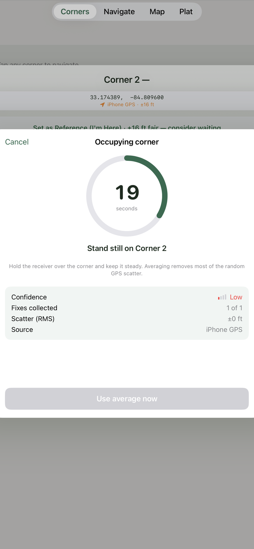
Set the duration in Settings → Anchor averaging: Instant, 15 s, 30 s, or 60 s. The default is 30 s. Longer occupation averages away more of the random error — use 60 s for the anchors you plan to solve a rotation from.
The confidence meter
Confidence tells you how much to trust the current position. On the Navigate screen it's a colored ring around the compass (green / amber / red) with an engraved “±ft” reading; it also appears as a four-bar meter in the GPS Source sheet. It's driven mainly by how far your fix wanders while you stand still — which is the honest measure, because a receiver's own accuracy claim can't detect multipath. A unit can report ±5 ft while sitting 14 ft from the truth.
| Level | What to do |
|---|---|
| High | Steady, and both receivers agree. Good moment to anchor. |
| Good | Fine for navigating; acceptable for anchoring. |
| Fair | Navigate, but wait before anchoring a corner. |
| Low | Don't anchor. Let the position settle first. |
When confidence drops to Fair or Low, a short line appears explaining why — "Position steady to ±3 ft", "Receivers disagree by 14 ft", or "Moving — stand still to measure". While you're walking the meter can't measure wander at all (your own travel would look like scatter), so it falls back to reported accuracy and won't claim High.
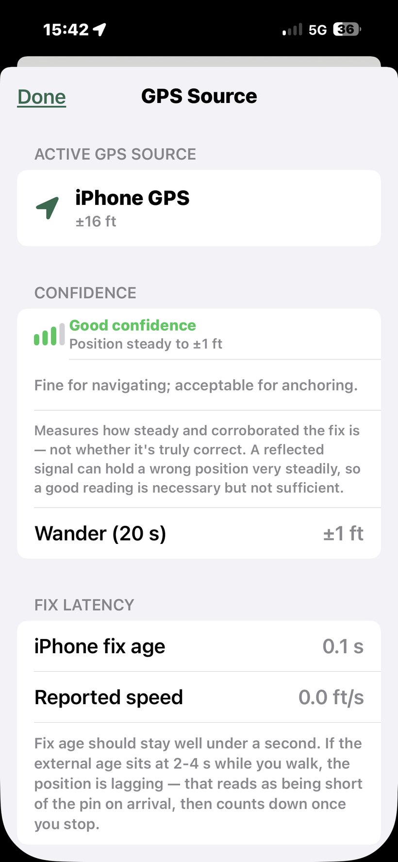
Open the full breakdown from the GPS Source sheet: it shows the active receiver, the confidence level and what's driving it, the 20-second wander figure, and fix latency — the age of the last fix. If latency sits at 2–4 seconds while you walk, the position is lagging, which reads as being short of the pin on arrival and then counting down once you stop.
Anchor quality
Once a corner is anchored, the Corners tab shows how good that anchor was — "Anchored at ±3 ft". If it exceeds about 10 ft it turns orange and suggests re-anchoring. That number is the floor on everything downstream, so it's worth glancing at before you spend an afternoon walking a parcel.
Don't re-anchor every time you arrive
This is the single most common way to get inconsistent results, and it's counter-intuitive.
Tapping I'm at [corner] on a corner that's already placed slides the entire boundary so that corner lands on your current fix. That's exactly what you want when you're deliberately re-placing the plat from a known monument. It is not what you want after walking to a corner and finding the distance reads 20 ft short — because in that case you're re-anchoring on a fix you already have reason to distrust, and dragging the whole parcel with it. The next leg then starts from a displaced boundary, and results swing back and forth.
The app now warns you: if anchoring would move the boundary further than your current fix quality justifies, you'll get a "Move the boundary?" confirmation showing how far it will shift and how good the fix is. The safe choice — Keep current placement — is the default.
Anchoring vs. rotating — how the workflow actually works
This trips people up, so it's worth stating plainly: tapping “I'm Here” places the plat — it never rotates it.
- Your first “I'm Here” lays out the whole boundary from that point, using the deed's shape and bearings as written.
- A later “I'm Here” slides the whole boundary so that corner lands on your position, and quietly records it as a second anchor.
Rotation is a separate, manual step. It only happens when you open ⋯ → Bearing Basis and tap Solve rotation. Nothing else turns the parcel — we made it opt-in because auto-solving from a noisy reading was throwing navigation off by 15–25 ft.
Most parcels never need it. If the corners land on the stakes from a single anchor, leave rotation alone — a correct deed shouldn't be rotated.
If the parcel plots crooked (older magnetic or “assumed” bearings), the sequence is:
- Stand on a known corner → I'm Here (places the plat).
- Walk to your farthest known corner → I'm Here (records a 2nd anchor; the plat slides but does not rotate yet).
- Open ⋯ → Bearing Basis → Solve rotation from 2 corners — this is the step that rotates the deed to fit both corners.
- Confirm it shows a green check, then tap Apply.
When to “Clear GPS Positions”
Clear GPS Positions (the ⋯ menu, or the top of the Plat sheet) is a full reset: it un-places the plat and erases every anchor and any solved rotation. You do not need it for ordinary re-anchoring — “I'm Here” already re-places things. Reach for it when:
- Re-solving rotation with a fresh set of anchors. Anchors are remembered between visits, and the solve uses all of them — so old or leftover anchors quietly corrupt the fit. Clear first, then anchor only the two far-apart corners you want to solve from.
- The app warns your anchors came from different receivers. Clear, then re-anchor every corner on one receiver so they share a single coordinate frame.
- You anchored the wrong corner, or on a poor fix, and the whole parcel shifted — clear and start over.
Solving rotation: baseline matters more than anything
If your deed plots rotated, the two-point solve fits the parcel to the corners you've physically anchored (see Understanding Survey Systems). Its accuracy depends almost entirely on how far apart your anchors are.
The angular error is roughly (position error ÷ baseline). The same 14 ft of GPS scatter produces:
| Baseline between anchors | Rotation uncertainty |
|---|---|
| 142 ft | ±5.6° — unusable |
| 300 ft | ±2.7° |
| 500 ft | ±1.6° |
So: anchor the two most distant corners you can reach, occupy each for 60 s, and solve once. Anchoring more corners helps further — a fit over five corners has far more redundancy than one over two. The app warns you when your anchors are too close together for the result to mean anything.
Reading the solved rotation
The solved rotation is shown in the same convention as magnetic declination: + is East, − is West. So −2.34° W means the deed's bearings sit 2.34° west of true north.
That's useful because you can compare it against historical declination for your area. If a deed used magnetic bearings, the rotation should match the declination at the time of the original survey — which may be many decades ago. A rotation that matches no plausible declination usually means an assumed meridian: an arbitrary basis tied to a fence, a road, or a prior plat. Both are common; only the document tells you which.